Wonderful Whitby
Staithes
Staithes is delightful and picturesque fishing port, situated approximately 11 miles north west of Whitby. It is a village steeped in history. Essentially, Staithes is a village of two parts. The top part of the village is accessed by the A174 Whitby Road, and then through the village, the second part by a very steep road called Staithes Lane.
The Port of Staithes
Staithes was once one of the largest fishing ports of North Yorkshire, but at this present time there are only a few full time fishermen. The design of the Yorkshire Coble is partly based on the Viking longboat, which was capable of landing on beaches. A number of cobles around this area are still beached when coming ashore.
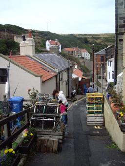
Lobster Pots on a narrow Staithes Street
The famous 'Staithes Bonnets were worn by the fishermens wives up until the 1960s. There was a Staithes Fishermans Choir but since its demise, it has been replaced by a Men of Staithes choir.
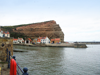
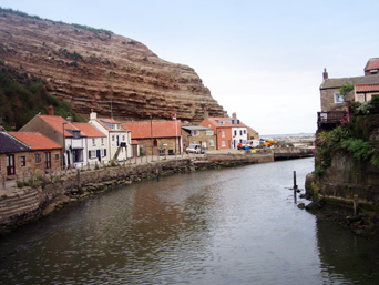
Roxby Beck Staithes
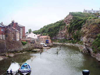
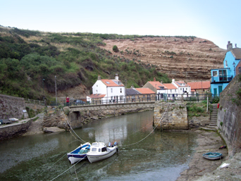
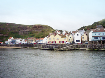
Staithes, called Steers by the locals, has a sheltered harbour, bounded by high cliffs and two breakwaters. Cowbar Nab to the left is where a number of small cottages form the small hamlet of Cowbar. The Lifeboat Station is situated here and is well worth a visit. Separating Cowbar and Staithes is Roxby Beck, also known as Staithes Beck, where brightly painted small fishing vessels are moored in shallow water. A footbridge spans the beck allowing access to Staithes. Penny Nab to the right is the opposite headland.
Footbridge across Roxby Beck
Captain James Cook lived here for a short time, working in a village store before leaving to live in Whitby, to take up an apprenticeship in shipbuilding. Another famous son is George Weatherill (1810-1890), who was born in Staithes and lived all his life in the Whitby area. He was called the Turner of the North. Clearly the area and its renowned beauty was instrumental in Staithes' popularity with artists. Many artists gathered here in the early 20th century, and were called the Staithes Group, including Lady Laura Knight and Frederick Jackson to name but two.
Cowbar and Cowbar Nab
In the old 1880 Methodist Chapel is the Captain Cook and Staithes Heritage Centre, which houses a host of memorabilia and antiquities, relating to the famous seafaring Captain James Cook and Staithes.
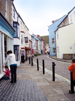
Cobbled Street in Staithes
Staithes Gallery is an elegant Georgian building, housing a collection of paintings and is open to the public. There are a number of restaurants, tea-rooms and gift shops, as well as a post office and antique shop. Staithes has bed and breakfast accommodation and self-catering accommodation. There are two public houses, The Royal George on the High Street and The Cod and Lobster on Seaton Garth. The Cod and Lobster public house has been subject to so much damage by the high waves, that it has had to be rebuilt several times over the centuries! Staithes has the narrowest street in the UK, called Dog Loup, it is 18" wide.
Staithes Village
There is a small sandy beach popular with families near Seaton Garth. Further along there is a rocky outcrop full of rock pools with starfish, anemones and small crustaceans. It is popular with fossil hunters and geologists being on the Dinosaur Coast. A popular find for children is fools gold, in fact, iron pyrites which look impressive but is worthless.
Two churches serve the village, St. Peter's Church of England in Church Street and the Catholic Church of Our Lady Star of the Sea on Staithes Lane, at the top part of the village. The upper part of Staithes is fairly modern in relation to the lower. There is a visitors car park, toilets and a small childrens play area. The Captain Cook Inn public house is situated here. Parking for the visitors cars is advisable here, as only residents cars are allowed lower down near the harbour. The Captain Cook Inn public house is situated here.
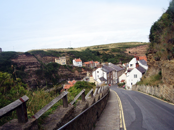
The Steep Hill down to old Staithes
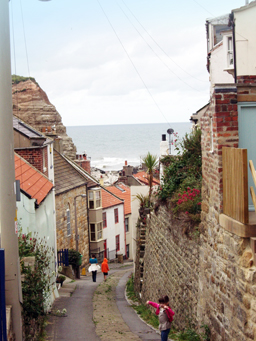
Narrow Street in Staithes
In 1883 a railway line was constructed between Middlesbrough and Whitby, via the coastal route passing near to Staithes, over the Staithes Viaduct. This was a 700 feet long iron and concrete structure, 150 feet high over the deep valley spanning the beck. This very exposed line was subject to high gales and north east winds resulting in restrictions of 20 mph when the winds blew, and the ringing of a bell to indicate that the winds were too strong. In 1960 Staithes station was closed and the viaduct dismantled. The old station is now a private dwelling not far from the Captain Cook Inn (previously The Station Inn). The southern part of the old viaduct was levelled and is under the public car park. The northern parapet can be seen on the hillside opposite.
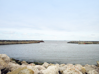
The North Sea, viewed from Staithes
Staithes is on the Cleveland Way National Trail. It is a popular 110 mile walk from Helmsley to Filey
whereby visitors can enjoy both the splendour and beauty of the North Yorkshire Moors and the magnificent, sometimes rugged and always
beautiful North Yorkshire Coast.
Visit the Cleveland Way website for more details, by clicking on the following link Cleveland Way National Trail
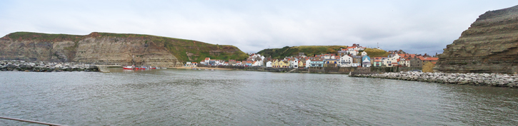
Panoramic view of Staithes
